Winston Bridge
From Wikishire
Revision as of 22:48, 17 September 2024 by RB (Talk | contribs) (Created page with "{{Infobox bridge |name=Winston Bridge |county 1=Durham |county 2=Yorkshire |picture=Winston Bridge from the South - geograph.org.uk - 133619.jpg |picture caption= |os grid ref...")
| Winston Bridge | |
| County Durham, Yorkshire | |
|---|---|

| |
| Location | |
| Type: | Stone arch |
| Carrying: | B6274 |
| Crossing: | River Tees |
| Location | |
| Grid reference: | NZ14231630 |
| Location: | 54°32’30"N, 1°46’53"W |
| Structure | |
| Length: | 111 feet |
| Type: | Stone arch |
| History | |
| Built 1762 – 1763 | |
| Information | |
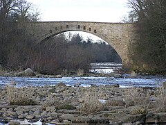
Winston Bridge carries the B6274 across the River Tees from Winston in County Durham on the north bank over to the North Riding of Yorkshire on the south bank.
The bridge as a survivor of the great flood of 1771. It was first built as a link in the road system carrying coal from South Durham pits to Yorkshire, but lost its importance with the coming of the railway. It is a stone bridge soaring high over the Tees. Designed by Sir Thomas Robinson of nearby Rokeby, and erected in 1762-3, it has one arch spanning 111 feet; which was once the longest single span in Britain. It has recently been strengthened with bolts to retain the spandrel walls.
References
- Winston Bridge: Bridges on the Tyne
| Bridges and crossings on the River Tees | ||||||
|---|---|---|---|---|---|---|
| Thorngate Footbridge | Abbey Bridge | Whorlton Bridge | Winston Bridge | West Tees Railway Bridge | Gainford Railway Bridge | Barforth Hall Bridge |