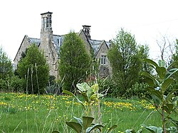
Carlton, Stanwick St John
| Carlton | |
| Yorkshire North Riding | |
|---|---|
 Carlton Green Farm | |
| Location | |
| Grid reference: | NZ192122 |
| Location: | 54°30’19"N, 1°42’14"W |
| Data | |
| Postcode: | DL11 |
| Local Government | |
Carlton is a tiny, churchless hamlet in the North Riding of Yorkshire, in the parish of Stanwick St John. It is found by the Aldbrough Beck, just under two miles south of the River Tees which marks Yorkshire's border with County Durham.
The two closest village, both under a mile from Carlton, are Stanwick St John to the south-west and Aldbrough St John to the south-east.
A mill is recorded in Carlton in 1558.
References
- A History of the County of York: North Riding - Volume 1 pp 127-134: Parishes: Stanwick St. John (Victoria County History)