Middleton, Northamptonshire
| Middleton | |
| Northamptonshire | |
|---|---|
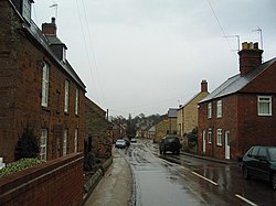
 Main Street, Middleton | |
| Location | |
| Grid reference: | SP840899 |
| Location: | 52°30’3"N, -0°45’50"W |
| Data | |
| Population: | 414 (2011) |
| Post town: | Market Harborough |
| Postcode: | LE16 |
| Dialling code: | 01536 |
| Local Government | |
| Council: | North Northamptonshire |
| Parliamentary constituency: |
Corby |
Middleton is a village in Northamptonshire close to the county boundary with Leicestershire. just to the west of the town of Corby, with Cottingham and East Carlton nearby.
There is a very steep hill known locally simply as "The Hill".
At the time of the 2011 Census, the parish's recorded population was 414.
The village's name means 'middle farm/settlement'.[1]
About the village
There is a pub with a restaurant - The Red Lion, Willow Cottage B & B and the Jurassic Way waymarked long-distance footpath passes through the village.
Outside links
| ("Wikimedia Commons" has material about Middleton, Northamptonshire) |
