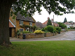
Harpole
| Harpole | |
| Northamptonshire | |
|---|---|

| |
| Location | |
| Grid reference: | SP691608 |
| Location: | 52°14’30"N, -0°59’27"W |
| Data | |
| Population: | 1,546 (2011) |
| Post town: | Northampton |
| Postcode: | NN7 |
| Dialling code: | 01604 |
| Local Government | |
| Council: | West Northamptonshire |
| Parliamentary constituency: |
Daventry |
Harpole is a village in Northamptonshire, four miles west of the county town, Northampton, along the A4500 road (formerly the A45) about a mile east of the M1 motorway junction 16.
There are two public houses, The Live and Let Live, on Larkhall Lane; and The Turnpike or Beefeater at the Harpole Turn from the A4500 road (former A45 road).
The village's name means "filthy pool".[1]
Geography and history
The M1 London to Yorkshire motorway junctions 16 and 15a are two miles west and three mlies south of Harpole respectively.
A Roman mosaic floor uncovered in 1846-48 identifies the site of a Roman villa north of the village.[2][3]
In April 2022 archaeologists found an Anglo-Saxon woman's grave, the Harpole bed burial, at a site in Harpole being developed for housing. It is an early Christian Anglo-Saxon burial site of a woman of high social standing. The discovery was announced in December 2022 and described as "the most significant early mediæval female burial ever discovered in Britain".[4]
Events
Harpole hosts a scarecrow weekend in September.[5] There is also an event in December where Santa drives around the village, as in, following him.
Outside links
| ("Wikimedia Commons" has material about Harpole) |
References
- ↑ "Key to English Place-names". http://kepn.nottingham.ac.uk/map/place/Northamptonshire/Harpole.
- ↑ A History of the County of Northampton - Volume 4 pp 73-74: Harpole (Victoria County History)
- ↑ History Gateway
- ↑ Hill, Amelia (7 December 2022). "Early mediæval female burial site is 'most significant ever discovered' in UK". The Guardian. https://www.theguardian.com/science/2022/dec/06/mediæval-female-burial-site-found-near-harpole-is-most-significant-ever-discovered-in-uk.
- ↑ Harpole Scarecrows
