Collingtree
| Collingtree | |
| Northamptonshire | |
|---|---|
 Church of S Columba, Collingtree | |
| Location | |
| Grid reference: | SP750557 |
| Location: | 52°12’36"N, -0°54’0"W |
| Data | |
| Population: | 1,138 (2011) |
| Post town: | Northampton |
| Postcode: | NN4 |
| Dialling code: | 01604 |
| Local Government | |
| Council: | West Northamptonshire |
| Parliamentary constituency: |
Northampton South |
Collingtree is a village in Northamptonshire, that has become in effect a part of the Northampton built-up area.
The village is about three miles from Northampton town centre, close to the A45 trunk road which heads east to Wellingborough and Peterborough. The M1 motorway is adjacent to the south-west side of the village and a road bridge connects Collingtree to the adjacent village of Milton Malsor, about a mile west.
Wootton Brook flows in a small valley through a golf course on the northern side towards West Hunsbury where it joins the River Nene before the river enters Northampton.
Name

In the Domesday Book the settlement is listed as Collingtrev or Colentreu. The most likely explaination is that uit is from the Old English Colinga treo, meaning 'Tree of Cola's people', after an otherwise unknown landowner, and a prominent or boundary tree.
Others suggest that the first element from the ancient British language, Colen meaning 'place' Still others have it that Colen is a version of the name of St Columba, to whom the village church was dedicated in 1170. In the 15th century the village is referred to as Colyngtrowgh and in the 17th century as Collingtrough
Another suggestion is that the latter element of the name is from trog, meaning 'trough'. A watering trough is certainly the basis for the name of the main road, Watering Lane, from the A45 up to the crossroads at the centre of the village.
History
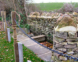
A spring bubbles up by the main road, Watering Lane, and cattle and later steam engines collected water from this spring. In 2006 its site was revealed when undergrowth was cleared back from the side of the road and the Parish Council decided to make a feature of it.
The centre of Collingtree is designated a Conservation Area, within which are several historic 17th- to 19th-century buildings, ten of them listed listed. It is noted that the layout of boundary walls and the use of local stone, combine to create a distinctive location with a strong sense of place, worthy of protection and enhancement.
The village has one of the most unusual High Streets in the land. It runs roughly north to south, has a pub, The Wooden Walls of Old England, but no shops and leads nowhere in either direction. The village grew on a route between Blisworth in the south and Wootton in the north. The southbound route was cut off in the 1950s by the building of the M1 motorway. The northern part was cut off when Collingtree Grange was built and is now cut off by the golf course. The oldest houses are 17th-century, of which four are listed, all in the High Street. No.43 is Grade II* listed. Another five listed buildings, in the High Street and Barn Corner are 18th-century. The form of the village is largely unchanged since about 1800 or earlier.
Outside links
| ("Wikimedia Commons" has material about Collingtree) |