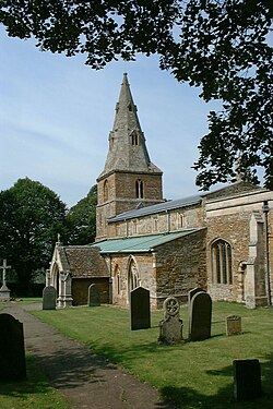
Wilbarston
| Wilbarston | |
| Northamptonshire | |
|---|---|
 All Saints' Church, Wilbarston | |
| Location | |
| Grid reference: | SP813883 |
| Location: | 52°29’12"N, -0°48’13"W |
| Data | |
| Population: | 753 (2011) |
| Post town: | Market Harborough |
| Postcode: | LE16 |
| Dialling code: | 01536 |
| Local Government | |
| Council: | North Northamptonshire |
| Parliamentary constituency: |
Kettering |
Wilbarston is a village in the norrth of Northamptonshire in the valley of the River Welland valley, which river marks the border with Leicestershire. Wilbarston is five miles from Market Harborough, a town spread across both counties, on the A427.
The 2011 Census recorded the parish's population as 753, including Pipewell and Carlton Purlieus.
The village's name means 'farm/settlement of Wilbeorht'.[1]
Outside links
| ("Wikimedia Commons" has material about Wilbarston) |
References
- ↑ Gover, J. E. B.; Mawer, A. & Stenton, F.M.: 'Place-Names of Northamptonshire , Part' (English Place-Names Society, 1933)
