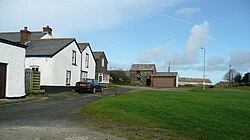
Woolley, Cornwall
| Woolley | |
| Cornwall | |
|---|---|
 West Woolley Farm | |
| Location | |
| Grid reference: | SS253167 |
| Location: | 50°55’24"N, 4°29’9"W |
| Data | |
| Postcode: | EX23 |
| Local Government | |
| Council: | Cornwall |
Woolley is a hamlet in the very northernmost part of Cornwall, a few hundred yards from the border of Devon to the north, and less than a mile from the source of the River Tamar, which shortly below that point flows southward bearing the borderline with it all the way to the sea.
Three miles to the west is Morwenstow, a village barely bigger, by Cornwall's rocky north coast.
| ("Wikimedia Commons" has material about Woolley, Cornwall) |
