Tunstall, North Riding
| Tunstall | |
| Yorkshire North Riding | |
|---|---|
 Tunstall | |
| Location | |
| Grid reference: | SE217958 |
| Location: | 54°21’29"N, 1°40’3"W |
| Data | |
| Population: | 271 (2011) |
| Post town: | Richmond |
| Postcode: | DL10 |
| Local Government | |
| Council: | North Yorkshire |
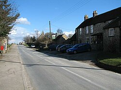
Tunstall is a village in the North Riding of Yorkshire, about two miles west of Catterick and the A1(M) motorway. It had a population of 271 at the 2011 census.
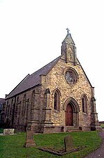
The village has a church, and Tunstall has one public house, The Bay Horse.
History
Tunstall was mentioned in the Domesday Book in 1096 as being "Land of Count Alan". The record shows the manor to have had 30 villeins. 16 bordars and a priest. Before the conquest, the manor was held by Earl Edwin.[1]
In 1870-72 John Marius Wilson's Imperial Gazetteer of England and Wales described Tunstall as:
"a township-chapelry in Catterick parish, N. R. Yorkshire; 3 miles S of Catterick-Bridge r. station. Post town, Catterick. Acres, 1,262. Real property, £2,139. Pop., 293. Houses, 66. The living is annexed to Catterick. The church was built in 1847. There are a Wesleyan chapel and a slightly endowed school."
Parish church
The church was built in 1846 as a chapel of ease to St Michael and All Angels in neighbouring Hudswell.[2][3] The building is a grade II listed building.[4]
References

- ↑ Tunstall, North Riding in the Domesday Book
- ↑ "Tunstall: Holy Trinity". https://www.achurchnearyou.com/church/3339/about-us/. Retrieved 15 January 2019.
- ↑ "Parishes: Catterick". https://www.british-history.ac.uk/vch/yorks/north/vol1/pp301-313. Retrieved 15 January 2019.
- ↑ National Heritage List 1157457: Church of the Holy Trinity (Grade II listing)
Outside links
| ("Wikimedia Commons" has material about Tunstall, North Riding) |
