Swinton, Malton
| Swinton | |
| Yorkshire North Riding | |
|---|---|
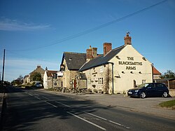
 The Blacksmiths Arms, Swinton | |
| Location | |
| Grid reference: | SE759732 |
| Location: | 54°8’58"N, -0°50’22"W |
| Data | |
| Population: | 608 (2011) |
| Post town: | Malton |
| Postcode: | YO17 |
| Local Government | |
| Council: | North Yorkshire |
| Parliamentary constituency: |
Thirsk and Malton |
Swinton is a little village in the North Riding of Yorkshire, found about two miles west of Malton on the B1257 road.
The village stands at the edge of the Howardian Hills 'Area of Outstanding Natural Beauty', which stretches out to the immediate north.
In the Domesday Book the vilage is recorded as 'Swintune',[1][2] which is derived from the Old English Swin tun, meaning 'pig farm'.[3]
The parish had 608 residents at the 2011 census.
Outside links
| ("Wikimedia Commons" has material about Swinton, Malton) |

References
- ↑ Swinton, Malton in the Domesday Book
- ↑ A History of the County of York: North Riding - Volume 1 pp 464-471: Parishes: Appleton le Street (Victoria County History)
- ↑ Ekwall, Eilert, The Concise Oxford Dictionary of English Place-Names. Oxford, Oxford University Press, 4th edition, 1960. p. 457 ISBN 0198691033
