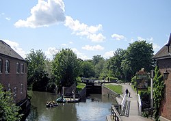
Newbury Lock


Newbury Lock is a lock on the Kennet and Avon Canal in the town centre of Newbury, Berkshire. It has a rise/fall of 3 ft 6 in, and is situated just upstream of Newbury Bridge.[1]
The lock is a Grade-II listed structure. It has brick walls that are capped with Bath Stone and which are wider at the top than at the base in an attempt to counteract frost damage. It was built in 1796, as part of the construction of the Kennet and Avon Canal linking Newbury and Bath. The canal was built under the supervision of John Rennie.[2][3][4]
Newbury Lock was the easternmost lock on the original Kennet and Avon Canal, and downstream it connected to what was the much older Kennet Navigation, opened in 1727 between Reading and Newbury. The canal opened throughout in 1810 and provided, along with the River Thames, the Kennet Navigation and the River Avon, a through route between London and Bristol. The Kennet Navigation was purchased by the Kennet and Avon Canal Company in 1812, and is now generally regarded as part of the Kennet and Avon canal.[2][4]
Adjacent to the lock is a sculpture called Ebb And Flow, created by the sculptor Peter Randall-Page. The work comprises a large granite bowl set at the centre of a spiral granite path leading down from the lock. The bowl is connected to the lock by underground piping so that when the lock fills, water flows into the bowl and then empties away as the level of the water in the lock goes down.[5]
References
- ↑ Pearson, Michael (2003). Kennet & Avon Middle Thames:Pearson's Canal Companion. Rugby: Central Waterways Supplies. ISBN 0-907864-97-X.
- ↑ 2.0 2.1 "Newbury Lock". historicengland.org.uk. https://historicengland.org.uk/listing/the-list/list-entry/1211989.
- ↑ Russell, John (1997). The Kennet & Avon Canal: A journey from Newbury to Bath in 1964. Bath: Millstream Books. p. 11. ISBN 0-948975-46-6.
- ↑ 4.0 4.1 "Kennet and Avon Canal". Newbury History. http://www.newburyhistory.co.uk/kennet-and-avon-canal.
- ↑ "Agenda for meeting on 24 June 2019". Newbury Town Council. 18 June 2019. p. 25. https://newbury.gov.uk/?mdocs-file=190.
Outside links
- Location map: 51°24’4"N, 1°19’33"W