West Grinstead
| West Grinstead | |
| Sussex | |
|---|---|
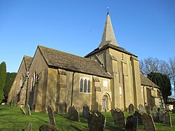
 St. George's Church, West Grinstead | |
| Location | |
| Grid reference: | TQ171207 |
| Location: | 50°58’27"N, 0°19’59"W |
| Data | |
| Population: | 3,054 (2011) |
| Post town: | Horsham |
| Postcode: | RH13 |
| Dialling code: | 01403 |
| Local Government | |
| Council: | Horsham |
| Parliamentary constituency: |
Arundel and South Downs |
West Grinstead is a village in the midst of Sussex, just off the B2135 road four miles north-west of Henfield. Despite the similarity of name, it is nowhere near East Grinstead, a town almost eighteen miles away at the county’s northern boundary. This village gives a name to the hundred in which it stands, the West Grinstead Hundred in the the Rape of Bramber.
The western River Adur flows through the village.
The wider parish of West Grinstead includes also Littleworth, Partridge Green and Dial Post. The 2011 Census recorded a parish population of 3,054.
Churches

- Church of England: St George's Church, which was built around 1100
- Roman Catholic: The Shrine Church of Our Lady of Consolation and St Francis, built in 1876
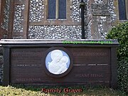
The Roman Catholic church is a centre of Catholic pilgrimage. Two notable figures are buried in its grounds: the Anglo-French writer and poet Hilaire Belloc and the writer Antonia White.[1]
History

Knepp Castle is located to the west of the village near the A24. It was a motte castle and founded in the 12th century by William de Braose. Some remains of the keep still stand.
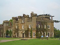
The modern Knepp Castle nearby is a castellated mansion by John Nash.[2]
Leisure
The Downs Link long-distance path runs through the parish and can be used for walking or cycling.
| ("Wikimedia Commons" has material about West Grinstead) |
References
- ↑ Vail, Anne (2004). Shrines of Our Lady in England. Leominster: Gracewing. p. 207. ISBN 0852446039. https://books.google.com/books?id=hjyc9bPITKgC&pg=PA207. Retrieved 26 June 2022.
- ↑ "Knepp Castle". Pastscape. http://www.pastscape.org.uk/hob.aspx?hob_id=396721.
