West Harting
| West Harting | |
| Sussex | |
|---|---|

| |
| Location | |
| Grid reference: | SU784212 |
| Location: | 50°59’8"N, -0°53’2"W |
| Data | |
| Population: | 100 (est.) |
| Post town: | Petersfield |
| Postcode: | GU31 |
| Dialling code: | 01730 |
| Local Government | |
| Council: | Chichester |
| Parliamentary constituency: |
Chichester |
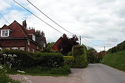
West Harting is a hamlet in Sussex, found just off the B2146 road two and a half miles south-east of Petersfield, the latter across the county border in Hampshire. The wider hamlet includes a hamlet of three houses named Quebec. All evidence suggests there was originally one main farm in the hamlet, named Manor Farm, which still exists to this day. However, there are several other farms which own the remainder of the land around West Harting in the hamlet's vicinity.
History
The hamlet is listed in the Domesday Book included in the large Manor of Harting along with South Harting and East Harting.[1]
Outside links
| ("Wikimedia Commons" has material about West Harting) |
References

This Sussex article is a stub: help to improve Wikishire by building it up.

