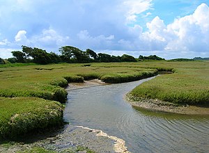
Pagham Harbour

Pagham Harbour is a small bay on the coast of the Manhood Peninsula on Sussex's south coast, on the western outskirts of Bognor Regis. The bay has just a narrow opening to the sea, and within is a tidal flat. Several small streams flow into Pagham Harbour, their changing courses traced across the mud at low tide, or lost in the sea at the flood.
An area of 1,554 acres of the harbour has ben designated a biological and geological Site of Special Scientific Interest.[1] It has also been designated a Geological Conservation Review site,[2] a Nature Conservation Review site,[1] a Ramsar site,[3] a Special Protection Area[4] and a Marine Conservation Zone.[5] An area of 1,480 acres is a Local Nature Reserve.[6]
The harbour forms an area of saltmarsh and shallow lagoons. It is not an estuary, as no major streams enter the harbour with the only freshwater inflow a few small streams draining surrounding fields.[7][8]
History
In earlier times Pagham Harbour was a working harbour with three ports. One port was situated at the western end, of the harbour near Sidlesham Mill: a tidemill was built in 1755 by Woodruffe Drinkwater of Chichester. It had three water-wheels, and eight pair of stones, capable of grinding a load of corn in an hour. After the attempt to drain the harbour in c. 1873, the mill was removed in 1876.[9] The harbour was then known as Wardur. The port of Charlton was at the entrance to the harbour and the third was on the Pagham side of the harbour and was known as the Port of Wythering (Wyderinges).[10]
The port of Wardur was part of 'New Haven' a development in the Middle Ages.[9] The Port of Wythering was overrun by the sea in the 13th century and the whole harbour eventually silted up and ceased to be navigable, except for small craft.[11]
An attempt was made to drain the harbour for farming in c. 1873 with an embankment constructed across the edge of the lagoon to hold back the sea; this failed during a storm in December 1910 and was not reconstructed.[12][13][7]
At present the entrance to the sea is 55 yards wide.[14]
Pagham Harbour today
Pagham Harbour today, is one of the few undeveloped stretches of the Sussex coast. It has a sheltered inlet. The harbour is designated as a nature reserve and is an internationally important wetland site for wildlife. It is 1,554 acres in size.[1] The Reserve is made up of saltmarsh and tidal mudflats with shingle, open water, reed swamp and wet permanent grassland habitats.[15]
Location
- Location map: 50°45’50"N, -0°45’54"W
- Streetmap: SZ872968
Outside links
| ("Wikimedia Commons" has material about Pagham Harbour) |
References
- ↑ 1.0 1.1 1.2 SSSI listing and designation for Pagham Harbour
- ↑ "Pagham Harbour (Coastal Geomorphology of England)". Joint Nature Conservation Committee. http://jncc.defra.gov.uk/default.aspx?page=4174&gcr=1851.
- ↑ "Designated Sites View: Pagham Harbour". Natural England. https://designatedsites.naturalengland.org.uk/SiteGeneralDetail.aspx?SiteCode=UK11052&SiteName=&countyCode=46&responsiblePerson=&unitId=&SeaArea=&IFCAArea=.
- ↑ "Designated Sites View: Pagham Harbour". Natural England. https://designatedsites.naturalengland.org.uk/SiteGeneralDetail.aspx?SiteCode=UK9012041&SiteName=&countyCode=46&responsiblePerson=&unitId=&SeaArea=&IFCAArea=.
- ↑ "Pagham Harbour Marine Conservation Zone". Department for Environment Food and Rural Affairs November 2013. http://publications.naturalengland.org.uk/publication/4680895541805056?category=1721481.
- ↑ "Pagham Harbour". Natural England. http://www.lnr.naturalengland.org.uk/Special/lnr/lnr_details.asp?C=0&N=pagham&ID=325.
- ↑ 7.0 7.1 "Changes of Pagham Harbour". University of Sussex. http://www.sussex.ac.uk/geography/researchprojects/coastview/Estuaries/pagham-slides.htm.
- ↑ Michael Shrubb (24 July 2003). Birds, Scythes and Combines: A History of Birds and Agricultural Change. Cambridge University Press. pp. 148–9. ISBN 978-0-521-81463-8. https://books.google.com/books?id=eeJsuTiGIbkC&pg=PA148.
- ↑ 9.0 9.1 A History of the County of Sussex - Volume 4 pp 210-215: Sidlesham (Victoria County History)
- ↑ A History of the County of Sussex - Volume 3 pp 100-102: The City of Chichester: The port (Victoria County History)
- ↑ A History of the County of Sussex - Volume 4 pp 227-333: Pagham (Victoria County History)
- ↑ A.J Prater (30 November 2010). Estuary Birds of Britain and Ireland. Bloomsbury Publishing. p. 192. ISBN 978-1-4081-3847-2. https://books.google.com/books?id=Yxsxe_ZEpY4C&pg=PA192-IA3.
- ↑ Cundy, A.B.; Long, A.J.; Hill, C.T.; Spencer, C.; Croudace, I.W. (August 2002). "Sedimentary response of Pagham Harbour, southern England to barrier breaching in AD 1910". Geomorphology 46 (3-4): 163–176. doi:10.1016/S0169-555X(02)00060-0. http://eprints.uwe.ac.uk/8948/.
- ↑ May, V.J.. "Pagham Harbour". Department for Environment, Food and Rural Affairs. http://jncc.defra.gov.uk/pdf/gcrdb/GCRsiteaccount1851.pdf.
- ↑ "Pagham Hrbour". West Sussex CC. http://www.westsussex.gov.uk/leisure/explore_west_sussex/wildlife_and_landscape/coastal_plain/pagham_harbour_local_nature.aspx.
