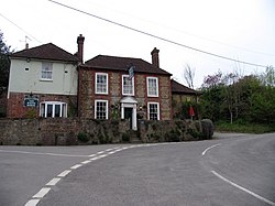
Sutton, Sussex
| Sutton | |
| Sussex | |
|---|---|

| |
| Location | |
| Grid reference: | SU979151 |
| Location: | 50°55’40"N, -0°36’30"W |
| Data | |
| Population: | 425 (2011) |
| Post town: | Pulborough |
| Postcode: | RH20 |
| Dialling code: | 01798 |
| Local Government | |
| Council: | Chichester |
| Parliamentary constituency: |
Arundel and South Downs |
Sutton is a village in Sussex, four miles south of Petworth and east of the A285 road.
The 2011 census recorded a population of 192 people in 83 households; the 2011 Census did not record the village separately.
There is a parish, St John the Baptist, and one pub, the White Horse.
About the village
Lords Piece at Coates within the parish is designated a Site of Special Scientific Interest, which at one time contained the entire known remaining British population of the field cricket Gryllus campestris.[1][2] Coates Castle is within the neighbouring parish of Fittleworth.
Outside links
| ("Wikimedia Commons" has material about Sutton, Sussex) |
References
- ↑ SSSI listing and designation for Lords Piece
- ↑ "Endangered cricket reintroduced in South East England". Wildlife Extra.com. May 2010. http://www.wildlifeextra.com/go/news/cricket-endangered.html#cr.
