Penhurst
| Penhurst | |
| Sussex | |
|---|---|
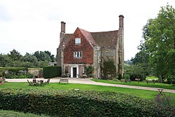
 Manor House, Penhurst | |
| Location | |
| Grid reference: | TQ867120 |
| Location: | 50°55’12"N, -0°24’36"E |
| Data | |
| Population: | 52 (2001) |
| Postcode: | TN33 |
| Dialling code: | 01424 |
| Local Government | |
| Council: | Rother |
| Website: | ashburnham-penhurst.net |
Penhurst is a village in Sussex, found on the Weald, four miles Battle.
The parish has few residents, according to the 2001 census Penhurst has just 52 inhabitants.
History
The name "Penhurst" means 'Pena's wooded hill' (Penan hyrst).[1] The village is recorded in the Domesday Book as Penehest.[2] The Abbey of Battle was its tenant-in-chief.[3]
About the village

There are 14 listed buildings in Penhurst.
Penhurst Manor is now a Christian retreat centre and is used much in the support of missionaries from overseas.
The 14th century parish church is dedicated to St Michael the Archangel. The actor Harry H Corbett (1925-1982) lies buried in the churchyard.[4]
Outside links
References
- ↑ Place-Names
- ↑ "Sussex F-P". The Domesday Book Online. http://www.domesdaybook.co.uk/sussex2.html#penhurst. Retrieved 23 February 2021.
- ↑ Penhurst in the Domesday Book
- ↑ "Penhurst". Sussex Online Parish Clerks. http://www.sussex-opc.org/index.php?k=1&t=Parish.