Nutbourne, Chichester
| Nutbourne | |
| Sussex | |
|---|---|
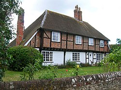
 A 16th century cottage in Nutbourne | |
| Location | |
| Grid reference: | SU788054 |
| Location: | 50°50’34"N, -0°52’55"W |
| Data | |
| Post town: | Chichester |
| Postcode: | PO18 |
| Local Government | |
| Council: | Chichester |
| Parliamentary constituency: |
Chichester |
Nutbourne is a village in the south-west Sussex, two miles east of Emsworth and the Hampshire border, on the A259 road.
This is a small village, on the south coast road that follows the track of a Roman road. This was the main road from the Hampshire cities to Chichester, until bypassed by the A27 trunk road. From Nutbourne a loop of road runs south into a little peninsula on which sits Chidham. The village is at the northern tip of Thorney Channel, an inlet of Chichester Harbour.
Outside links
| ("Wikimedia Commons" has material about Nutbourne, Chichester) |
