Newtimber
| Newtimber | |
| Sussex | |
|---|---|
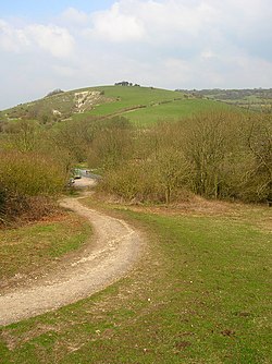
 Newtimber Hill | |
| Location | |
| Grid reference: | TQ271138 |
| Location: | 50°54’35"N, 0°11’36"W |
| Data | |
| Population: | 96 (2001) |
| Post town: | Hassocks |
| Postcode: | BN6 |
| Dialling code: | 01273 |
| Local Government | |
| Council: | Mid Sussex |
| Parliamentary constituency: |
Arundel and South Downs |
| Website: | Newtimber Parish |
Newtimber is a small village in Sussex, to the north-west of Brighton. The parish also includes the hamlet of Saddlescombe.
The parish lies almost wholly with the South Downs National Park, Above the village is a downland scarp which includes Newtimber Hill, Newtimber Holt, much of which is designated a 'Site of Special Scientific Interest'.
Parish Church
The Church of St John the Evangelist is of the 13th century: however the mediæval work has been largely overlaid by restoration work performed in 1875. The tower was added in 1839.[1]
About the village
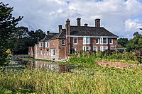
Newtimber Place, the manor house, is a moated house by the village. The oldest portion was built by the Bellingham family in the 16th century, but the main portion dates from the late 17th century.[2]
The hills above the village carry a wealth of ancient remains, including a bowl barrow on North Hill,[3] a circular mound with a deep central hollow, indicating partial excavation in the past; a rgoup of three bowl barrows, and an Anglo-Saxon mixed cemetery on Summer Down.[4]
Saddlescombe

Saddlescombe (TQ272114) is a hamlet in the Newtimber parish; it stands beside the road from Poynings to Brighton, five and a half miles north-west of Brighton.
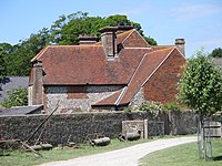
Saddlescombe Farm, at the base of the Downs, has been owned by the National Trust along with the surrounding countryside since 1995. It has been a working farm since the Domesday Book, and belonged to the Knights Templar for around 100 years[5] The ancient well in middle of the village green is probably the only visible relic of the manor and the donkey wheel above it that wound up the hamlet's water is still intact.[6] There are rusting iron oxen shoes tacked to the old doorway farmhouse.
The hamlet consists of several threshing barns, large storage barns, a variety of houses, forge, cattle yard and dairy, duck pond, donkey wheel, pig sties, chicken coops and old stables.
Newtimber Place


- Main article: Newtimber Place
Newtimber Place (TQ269137) is a 16th-century house, likely built by Richard Bellingham, who had served as the sheriff of Sussex,.[7] It has a wide moat which goes right up to its walls, with white bridge that is fed by clear, chalk spring water. It has a giant turkey oak tree outside.
To the west of the house is Newtimber Wood (TQ266134). This is an intact hazel and hornbeam coppice with fine oaks and ash that borders on Park Wood in the neighbouring parish of Poynings. Both woods are botanically rich.
Outside links
|
|
- Newtimber Parish
- The Downland Benefice: Newtimber Church
- Saddlescombe Farm and Newtimber Hill: National Trust]
- A History of the County of Sussex - Volume 7 pp 204-208: Parishes: Newtimber (Victoria County History)
References
- ↑ National Heritage List 1354879: The Parish Church of St John Evangelist (Grade II* listing)
- ↑ National Heritage List 1025629: Newtimber Place (Grade I listing)
- ↑ National Heritage List 1014949: Bowl barrow on North Hill (Scheduled ancient monument entry)
- ↑ National Heritage List 1014952: Group of three bowl barrows and an Anglo-Saxon mixed cemetery on Summer Down (Scheduled ancient monument entry)
- ↑ A History of the County of Sussex - Volume 2 p : Houses of Knights Templar - Preceptory of Saddlescombe (Victoria County History)@Houses of Knights Templar - Preceptory of Saddlescombe | A History of the County of Sussex: Volume 2 (pp. 92)]
- ↑ A History of the County of Sussex - < Volume 7 pp 204-208<: Parishes: Newtimber (Victoria County History)
- ↑ Bangs, David (2018). Land of the Brighton line : a field guide to the Middle Sussex and South East Surrey Weald. [Brighton]. ISBN 978-0-9548638-2-1. OCLC 1247849975. https://www.worldcat.org/oclc/1247849975.
