Blackham
| Blackham | |
| Sussex | |
|---|---|
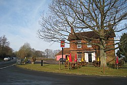
 The Sussex Oak, Blackham | |
| Location | |
| Grid reference: | TQ493399 |
| Location: | 51°8’21"N, -0°7’60"E |
| Data | |
| Post town: | Tunbridge Wells |
| Postcode: | TN3 |
| Dialling code: | 01892 |
| Local Government | |
| Council: | Wealden |
| Parliamentary constituency: |
Wealden |
Blackham is a hamlet in Sussex: it is in the east of the county, close by the border of Kent which snakes around to the north and east marked by the Kent Water. Its nearest town is Royal Tunbridge Wells, which stands approximately five and a half miles east of the village in Kent and overspilling the county border.
The name 'Blackham' is locally said to be derived from 'Black Hamlet' and comes from the village's being known as the resting place for smugglers returning from the coast with their booty as it was exactly one day's ride from Dover. At the time, it was described as a 'den of iniquity' due to the raucous and often violent behaviour of the smugglers.
Hever Castle (the childhood home of Anne Boleyn), Penshurst Place and Bolebroke Castle, all regularly frequented by King Henry VIII are all within four miles of Blackham as is the village of Hartfield - the home of Christopher Robin, Winnie-the-Pooh, and the actual "Pooh Bridge" location in Ashdown Forest, where people still play poohsticks.