Barlavington
| Barlavington | |
| Sussex | |
|---|---|

| |
| Location | |
| Grid reference: | SU972160 |
| Location: | 50°56’9"N, -0°37’3"W |
| Data | |
| Population: | 117 (2001) |
| Post town: | Petworth |
| Postcode: | GU28 |
| Dialling code: | 01798 |
| Local Government | |
| Council: | Chichester |
| Parliamentary constituency: |
Arundel and South Downs |
| Website: | Barlavington Parish Council |
Barlavington is a small village in Sussex, found four miles south of Petworth, to the east of the A285 road.
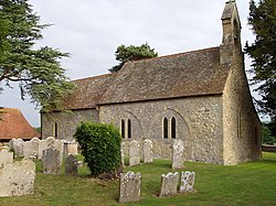
The parish church, St Mary's, was built between 1160 and 1190. Most of the church was built in Early English style.
The 2001 census recorded a parish population of 117 people living in 35 households. Owing to the presence of a retirement home only 36 people were economically active. The 2011 did not record the village specifically.
Outside links
| ("Wikimedia Commons" has material about Barlavington) |
- Barlavington in the Domesday Book
