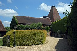
Wyck, Hampshire
| Wyck | |
| Hampshire | |
|---|---|
 Wyck oast house | |
| Location | |
| Grid reference: | SU756395 |
| Location: | 51°8’60"N, -0°55’10"W |
| Data | |
| Post town: | Alton |
| Postcode: | GU34 |
| Local Government | |
| Council: | East Hampshire |
| Parliamentary constituency: |
East Hampshire |
Wyck is a hamlet in the east of Hampshire, a mile north-east of the village of East Worldham, two and a half miles east of Alton, just off the B3004 road. It has a total of 24 households, three of which are in the Wyck Place Estate.
This is a small hamlet, given over to agriculture, within walking distance from its closest neighbours, East Worldham and Binsted.
History
Local tradition rumours that there was a small monastery on Monkwood Hill which would have owned all the land, but if so, all evidence was destroyed during the reign of King Henry VIII. The main feature today is the old oast house.
Outside links
| ("Wikimedia Commons" has material about Wyck, Hampshire) |
