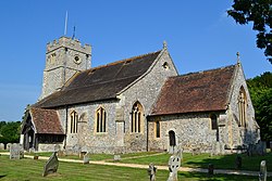
Longparish
| Longparish | |
| Hampshire | |
|---|---|
 St Nicholas, Longparish | |
| Location | |
| Grid reference: | SU434448 |
| Location: | 51°12’4"N, 1°22’44"W |
| Data | |
| Population: | 716 |
| Post town: | Andover |
| Postcode: | SP11 |
| Dialling code: | 01264 |
| Local Government | |
| Council: | Test Valley |
| Parliamentary constituency: |
North West Hampshire |
Longparish is a village in Hampshire. It is composed of four hamlets which over time have expanded and effectively joined up to become one village:
- Middleton;
- East Aston;
- West Aston; and
- Forton
Longparish stands on the north-west bank of the River Test, to the west of Andover. The 2011 census recorded a population (including Firgo and Forton) of 716.
Name
The name Longparish was first used in the mid-16th-century and is derived from a nickname for the "long parish" of Middleton, consisting of the settlements of Middleton, East Aston, West Aston and Forton, which stretched some four miles along the River Test.[1][2] The parish of Middleton ius first recorded as "Middletune" in the Domesday Book of 1086.
Landmarks
A 19th-century monument, Dead Man's Plack, stands nearby.[3]
Outside links
| ("Wikimedia Commons" has material about Longparish) |
References
- ↑ A History of the County of Hampshire - Volume 4 pp 406-409: Parishes: Longparish (Victoria County History)
- ↑ Spaul, John (2004). Andover 950—1974. Andover: Aluric Press. pp. 176–177. ISBN 978-0-954-82340-5.
- ↑ @"Deadman's Plack Monument, Longparish". British Listed Buildings. http://www.britishlistedbuildings.co.uk/en-139701-deadman-s-plack-monument-longparish.
- Rev. Martin Coppen (editor): 'St Nicholas, Longparish: A Church Guide' (2009; available from the church)
