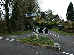
Kitwood
| Kitwood | |
| Hampshire | |
|---|---|
 Road junction in the centre of Kitwood | |
| Location | |
| Grid reference: | SU665330 |
| Location: | 51°5’35"N, 1°3’4"W |
| Data | |
| Post town: | Alton |
| Postcode: | SO24 |
| Dialling code: | 01420 |
| Local Government | |
| Council: | East Hampshire |
Kitwood is a hamlet spread along a lane in the parish of Four Marks, Hampshire, to the south-east of Four Marks itself.
The hamlet grew up at the junction of Kitwood Road and Swelling, it has spread alongthe lane all the way from Swelling hill pond to Kitwood farm near Hawthorn Road.
This place is mentioned in a document of 1403 as kyteswode. The name is from the words 'Kite's wood', from the birds which hunted here. The actual woodland that is referred to stood somewhere near to where Kitwood Plantation (SU677333).
History
The earliest signs of occupation in Kitwood are a number of Neolithic flint implements. It is also suggested that Swelling Lane, leading west toward Ropley from the hamlet, is the remains of a Roman Road. Saxon traces have not been found: it has been suggested that a potential Saxon waterway leads from a postulated Roman villa at Old Down Woods to Four Marks pond, but no archaeological evidence has yet been found for this theory.
More is known about Kitwood in the Middle Ages. The first records appearing in the early 15th century. The hamlet has evidence of mediæval settlement with mediæval potsherds found around the area. A court roll record from 1413 [1] mentions "kitteswodeweye". During a hedgerow dating survey, the hedgerow on either side of Kitwood Lane was dated to "approximately 800 years old". This wealth of records suggests significant activity in the area since the 1400s.
Just west of the "Kitwood Junction" (SU67133337) long, parallel field boundaries running on a north-east to soiuth-west alignment are visible. These are said to be have been laid as a result of the local Inclosure Act in 1709.[2] The 1839 Ropley Tithe Map[3] preserves some surnames of these early 1700s post enclosure tenants in the field names such as Withers piece and Davis' piece.
Outside links
References
- ↑ held in the records of Winchester College
- ↑ Heal, Chris, Ropley's Legacy, The Ridge Enclosures, 1709 to 1850: Chawton, Farringdon, Medstead, Newton Valence and Ropley and the birth of Four Marks (Chattaway and Spottiswood, Four Marks 2021) ISBN 978-1-9161944-3-4
- ↑ "Transcription of the 1839 Tithe Map Awards". https://www.ropleyhistory.org.uk/catalogue_item/manni-kirchner-collection/ropley-award-transcription-for-tithe-maps.