Harbridge
| Harbridge | |
| Hampshire | |
|---|---|
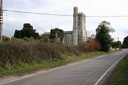
 Harbridge Church | |
| Location | |
| Grid reference: | SU144101 |
| Location: | 50°53’28"N, 1°47’46"W |
| Data | |
| Post town: | Ringwood |
| Postcode: | BH24 |
| Dialling code: | 01425 |
| Local Government | |
| Council: | New Forest |
| Parliamentary constituency: |
New Forest West |
Harbridge is a small village located some two and a half miles north of Ringwood and a similar distance south of Fordingbridge, in south-western Hampshire.
Overview
The village of Harbridge is at the edge of the low meadow land to the west of the River Avon.[1] To the south lies Somerley, home of the Earls of Normanton.
History
The name Harbridge probably means "Hearda's bridge".[2] In the Domesday Book of 1086, Bernard the Chamberlain held Harbridge from the King. Before 1066 it had been held by Ulveva. Harbridge is a referred to as a manor by the early 15th century.[1] In the early 19th century the manor passed to the Earl of Normanton, and like nearby Ibsley and Ellingham became part of his estate of Somerley.[1]
The church of All Saints consisting of chancel, nave, and west tower, was rebuilt in 1838.[1] The tower retains its 15th-century masonry, but it was raised in the 19th century reconstruction. Coade stone was used for various decorative elements during its reconstruction.[3]
Outside links
| ("Wikimedia Commons" has material about Harbridge) |
References
- ↑ 1.0 1.1 1.2 1.3 A History of the County of Hampshire - Volume 4 pp 604-606: Parishes: Harbridge (Victoria County History)
- ↑ Harbridge, Old Hampshire Gazetteer
- ↑ Nikolaus Pevsner: The Buildings of England: Hampshire & The Isle of Wight, 1967 Penguin Books ISBN 978-0-300-09606-4page 324
