Goodworth Clatford
| Goodworth Clatford | |
| Hampshire | |
|---|---|
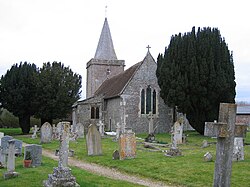
 St Peter's Church, Goodworth Clatford | |
| Location | |
| Grid reference: | SU366425 |
| Location: | 51°10’51"N, 1°28’36"W |
| Data | |
| Population: | 760 (2011) |
| Post town: | Andover |
| Postcode: | SP11 |
| Dialling code: | 01264 |
| Local Government | |
| Council: | Test Valley |
| Parliamentary constituency: |
North West Hampshire |
Goodworth Clatford is a village beside the River Anton in Hampshire. It is in the north-west of the county, south of Andover. Originally this was two villages, Goodworth and Lower Clatford, which grew together as one.
Most of the village is on the west side of the river, but the river is bridged here and the village spills over. The parish church, St Peter's, is on the east side.
The neighbouring village to the north is Upper Clatford, to the south where the Anton meets the River Test, is Fullerton.
There are two pubs (the Royal Oak and The Clatford Arms), a village shop and a primary school.
Society and sport
- Bellringing
- Gardening society
- Neighbourhood watch scheme.
- Uniformed organisations:
- Brownies
- Guides
- Scouts
- Tennis club, with two popular tennis courts
The Village Hall hosts events. The recreation ground has been enrolled as a Queen Elizabeth II Field.
About the village
Goodworth Clatford has large park, and beside the river is a nature area,
Outside links
| ("Wikimedia Commons" has material about Goodworth Clatford) |
