Withington
| Withington | |
| Lancashire | |
|---|---|
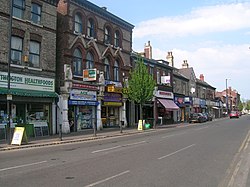
 Withington village centre, from Wilmslow Road | |
| Location | |
| Grid reference: | SJ848929 |
| Location: | 53°25’59"N, 2°13’44"W |
| Data | |
| Population: | 13,422 (2011) |
| Post town: | Manchester |
| Postcode: | M20 |
| Dialling code: | 0161 |
| Local Government | |
| Council: | Manchester |
| Parliamentary constituency: |
Manchester Withington |
Withington is a Lancashire village which has effectively become a mere suburb south of the City of Manchester. Withington is four miles south of Manchester city centre, and about half a mile south of Fallowfield, and the same north-east of Didsbury. It is a mile east of Chorlton-cum-Hardy. Withington had a recorded population of 13,422 at the 2011 census.
In the early 13th century, Withington occupied a feudal estate that included the townships of Withington, Chorlton-cum-Hardy, Moss Side, Rusholme, Burnage, Denton and Haughton, held by the Hathersage, Longford and Tatton families,[1] and within the Manor of Manchester and the Hundred of Salford in Lancashire.
Withington was largely rural until the mid-19th century when it experienced rapid socioeconomic development and urbanisation due to the Industrial Revolution, and Manchester's growing level of industrialisation. Withington became effectively part of Manchester, absorbed within its civic jurisdiction in 1904.[2]
Today, the residents of Withington comprise a mixture of families, university students and affluent "young professionals"—often themselves former students.[3] This is in a large part due to its education links—particularly the proximity to the University of Manchester and Manchester Metropolitan University. As a consequence, Withington is predominantly an area of mixed affluence. It is also a centre for clinical excellence with one of the largest cancer treatment centres in Europe—Christie Hospital—and Withington Community Hospital.
History
Middle Ages
In Anglo-Saxon times the area was sparsely settled. Didsbury may have been established in King Edward the Elder's reign as a fortification against the Danes. Following the Norman Conquest the lands of south Lancashire were granted to Roger of Poitou and by the early 13th century the Manor of Withington appears to be a sub-manor of the Manor of Manchester.[4]
The first recorded description of Withington dates from 1186, calling the area a willow-copse farmstead, and giving rise to the Old English name Wiðign-tun (referring to withies; willow branches used for bundling.[5] In the early 13th century, the Manor of Withington covered a wide area including Withington, Didsbury, Chorlton-cum-Hardy, Moss Side, Rusholme, Burnage, Denton and Haughton. The first Lord of the Manor of Withington is thought to have been William, son of Wulfrith de Withington.[1]

Withington was one of the townships of the parish of Manchester and a sub-manor of the Manor of Manchester. In the 13th century, Robert Grelle (sometimes Grelley),[6] Lord of the Manchester Manor, granted free warren in Withington to Matthew de Hathersage (or Haversage), son of William, in exchange for one knight's fee.[1] Little is known of the Hathersage family, except that they descended to the Longford family, and are connected with the manors of Hathersage and Longford, both in Derbyshire.[7] The lordship of Withington remained in the Hathersage/Longford family for over 300 years.[7]
Tudor, Stuart and Georgian periods
At the end of the 16th century, Nicholas Longford sold Withington to the Mosleys (originally 'Moseley'), an influential Anglo-Irish family of wool merchants who subsequently became wealthy landowners in Staffordshire:[7] Nicholas Mosley later became Lord of the Manor of Manchester. Hough End Hall was built by Sir Nicholas Mosley in 1596 as the new Withington manor house—the original mediæval manor house was situated south-east of the modern junction of Mauldeth Road West and Princess Road, which was surrounded by a moat. In 1750 it was demolished to make way for a farm building, but some of the moat was left. An Ordnance Survey map of 1845 shows it as "Withington Old Hall", and it later came to be known as "Chorlton's Farm" or "Old Hall Farm". Today, the site is occupied by Eddisbury Avenue and no trace remains of the old house.[8] There are still today some remnants of this moat underneath Old Moat Primary School, on Old Moat Lane. In the early 18th century, the Withington Manor was once again sold, this time to the Egertons of Tatton.[9]
Withington as a village developed around Wilmslow Road, a Turnpike Road, administered by the Manchester to Wilmslow Turnpike Trust which was the only direct route between Manchester and Wilmslow at the time. Farming still dominated the area, although there is evidence in maps of a substantial cotton house on Cotton Lane, which later appears to become Withington Hall. Some historians dispute the cotton house as there is little record of it, and claim "Cotton Lane" comes from land in the area which was jointly held by the townships of Withington, Didsbury and Burnage (a relic of the mediæval open field system). This area was the old village centre however, although the only relic of its former importance is the small flower display on the corner of Wilmslow Road and Cotton Lane.
Victorian and later periods

The trade in Withington, and consequent traffic on Wilmslow Road, increased steadily as the city of Manchester flourished in the early 19th century. Turnpike roads subsequently became increasingly unpopular, and were abolished completely in 1881. Wilmslow Road as a turnpike road would have been abolished as soon as 1861 had the Manchester to Wilmslow Turnpike Trust not agreed to build a new turnpike road to Northenden, named Palatine Road. Cheaper transport in and out of Manchester became an important factor in the growth of the area. In 1880 a tramway was built along Wilmslow Road and Palatine Road to the newly opened Withington and West Didsbury railway station, run by the Midland Railway. The horse trams ran until 1 December 1902 when the first electric trams came into operation. The train service from Withington and West Didsbury railway station to Manchester Central railway station operated until Didsbury railway station closed in 1961.
Withington's Parish Church of St Paul was built in 1841, and many other chapels and churches proliferated, including Methodist, Presbyterian and Roman Catholic. (The architects of St Paul's Church were Hayley & Brown and it was extended in 1864.)[10] Withington has also been home to Spanish and Portuguese Sephardi Jews: synagogues opened in the late 19th century.
Aviation
A large aerodrome was built in 1917-18 on the westerly edge of Withington, to the southwest of the junction of Mauldeth Road and Princess Road, on what is now the site of Houghend Playing Fields. The official name was Alexandra Park Aerodrome, but it was also variously referred to as "Withington" and "Didsbury". Closure came in autumn 1924 when Lord Egerton of Tatton would not agree to the site's continued use for flying. The large hangars were then demolished and Princess Road extended southwards through the eastern edge of the site.[11]
On 28 April 1910, French pilot Louis Paulhan landed his Farman biplane in Barcicroft Fields, Pytha Fold Farm, on the borders of Withington, Burnage and Didsbury, at the end of the first powered flight from London to Manchester, with a six-hour overnight stop near Lichfield, Staffordshire. Paulhan beat the British contender, Claude Grahame-White, winning a £10,000 prize offered by the Daily Mail.[12] Two special trains were chartered to Burnage railway station to take spectators to the landing. Paulhan's progress was followed throughout by a special train carrying his wife, Henri Farman and his mechanics. A house in Paulhan Road is marked by a blue plaque to commemorate his achievement.
Sights of the village


Withington today has a number of buildings of interest including several Grade II listed buildings. They include:
- Hough End Hall (1596), Nell Lane, Chorlton-cum-Hardy (Withington's Manor House)
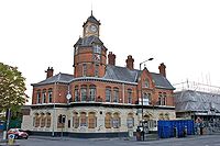
- Manchester and County Bank (1890), Wilmslow Road (now NatWest)
- St Paul's Parish Church, Wilmslow Road (1841)
- The Red Lion Inn (17th century)
- The Victoria public house
- The White Lion public house, Wilmslow Road (1841), now a supermarket
Other places of historical interest in Withington include:
- Christie Hospital – founded in 1892, the hospital moved to Withington in 1932. It is one of the largest cancer research and treatment centres in Europe. Christie's pioneered the therapeutic use of X-Rays in 1901, and in 1944 the world's first clinical drug trial was carried out here
- The Scala Cinema (1912–2008), Wilmslow Road – this was the oldest cinema in Manchester. Later renamed Cine City, it is now demolished and the site is awaiting redevelopment
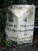
- Milestone, Wilmslow Road – outside the fire station, inscribed "8¼ miles to Wilmslow / 4 miles to Manchester to centre of St. Ann's"
- The Old Forge, Wilmslow Road (1881) – now private flats
- St Cuthbert's Roman Catholic Church, Wilmslow Road (1881)
- The Water Trough (1876), now on Copson Street – a stone drinking trough for horses, inscribed with an Old Testament passage: "that ye may drink, both ye and your cattle, and your beasts." (II Kings III:17)
- Withington Library (1927), Wilmslow Road, designed by Henry Price
- Withington Methodist Church, Wilmslow Road (1865)
Outside links
| ("Wikimedia Commons" has material about Withington) |
- ↑ 1.0 1.1 1.2 Sussex, Gay; Helm, Peter (1988). Looking Back at Withington and Didsbury. Willow. p. 45. ISBN 0-946361-25-8.
- ↑ Withington history
- ↑ "Withington, Manchester, UK". BBC Editorial. 6 June 2005. http://www.bbc.co.uk/dna/h2g2/A3895491. Retrieved 17 March 2008.
- ↑ France and Woodall (1976) pp. 3 ff.
- ↑ Cooper, Glynis (2005). The Wharncliffe Companion to Manchester. Wharncliffe books. p. 168. ISBN 1-903425-74-3.
- ↑ Townships – Heaton Norris
- ↑ 7.0 7.1 7.2 Township – Withington
- ↑ France, Ernest & Woodall, Thomas F. (1976). A New History of Didsbury. E. J. Morten, Didsbury. p. 203. ISBN 0-85972-035-7.
- ↑ Lloyd, John M. (1972) The Township of Chorlton-cum-Hardy. Didsbury, Manchester: E. J. Morten; pp. 109–110
- ↑ Nikolaus Pevsner: Pevsner Architectural Guides
- ↑ Scholefield, R. A. (2004). Manchester's Early Airfields – an extended chapter in: Moving Manchester. Lancashire & Cheshire Antiquarian Society. pp. 216–219.
- ↑ "London to Manchester". Skypark. 2007. http://www.skyparksecure.com/cheap_airport_parking/manchester/airport_history.php. Retrieved 17 March 2008.
