Empshott
| Empshott | |
| Hampshire | |
|---|---|
 Holy Rood, Empshott | |
| Location | |
| Grid reference: | SU752312 |
| Location: | 51°4’34"N, -0°55’37"W |
| Data | |
| Post town: | Liss |
| Postcode: | GU33 |
| Local Government | |
| Council: | East Hampshire |
| Parliamentary constituency: |
East Hampshire |
Empshott is a village in Hampshire, three and a half miles south-west of Bordon, its nearest town, in the east of the county close to the borders of Surrey and Sussex. The village of Liss, which is stroked by the latter border, is five miles to the south-east.
To the west the land rises steeply in a scarp formation known as the East Hampshire Hangers. Goleigh Hill (722 feet) and Noar Hill (702 feet) are two of the highest points in the county which forms parts of the Hampshire Downs. The River Rother has its source in the village.
Church
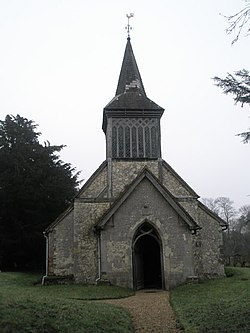
The village church, Holy Rood Church, dates to the 13th century.[1] Later additions include a Victorian bell-turret.[1]
History
Empshott is listed in the 1086 Domesday survey as being held by Geoffrey the Marshal, having been granted the land from pre-conquest landowners Bondi the Constable and Saxi of Clatford after 1066. The hamlet comprised four villagers and a mill.[2]
Outside links
| ("Wikimedia Commons" has material about Empshott) |
References
- ↑ 1.0 1.1 Nikolaus Pevsner: The Buildings of England: Hampshire & The Isle of Wight, 1967 Penguin Books ISBN 978-0-300-09606-4
- ↑ Empshott in the Domesday Book
