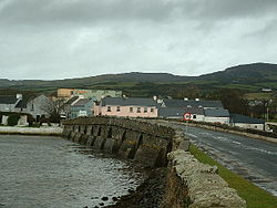
Malin, County Donegal
| Malin Irish: Málainn | |
| County Donegal | |
|---|---|
 Malin Bridge | |
| Location | |
| Grid reference: | C467453 |
| Location: | 55°15’0"N, 7°16’12"W |
| Data | |
| Population: | 92 (2016) |
| Local Government | |
| Dáil constituency: |
Donegal |
Malin is a village in County Donegal, found four miles north of Carndonagh. A further eight miles to the north is Malin Head, the most northerly point of the island of Ireland[1]
This was a planned settlement plotted around a triangular green.
Sport
- Gaelic sports: Malin GAA; the most northerly sited GAA club in Ireland
The Malin 5k run is held annually, and there is also a raft race which takes place to raise funds for the RNLI.
Outside links
References
- ↑ Homer, Peter. A Brief History of Malin Head. Inishowen Maritime Museum & Planetarium. 2014.
- Málainn/Malin: Placenames Database of Ireland

This County Donegal article is a stub: help to improve Wikishire by building it up.