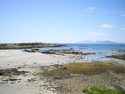
Kilmory, Argyllshire
| Kilmory Gaelic: Cill Mhoire | |
| Argyllshire | |
|---|---|
 Kilmory beach | |
| Location | |
| Grid reference: | NM529700 |
| Location: | 56°45’22"N, 6°2’35"W |
| Data | |
| Post town: | Fort William |
| Postcode: | PH36 4 |
| Local Government | |
| Council: | Highland |
Kilmory is a small crofting hamlet on the north coast of Ardnamurchan, in north-western Argyllshire.[1]
The name of the village, Cill Mhoire, means "Mary's Cell" or "Church of Mary".
Geography
Kilmory is reached by a branch road off the B8007 road that runs from Salen to Achosnich by way of Kilchoan. All the roads in Ardnamurchan are single track. There is a view north from the junction with the B8007 to the islands of Rhum, Eigg, Muck and Canna. The road descends northwards, crosses the Achateny Water that drains Loch Mudle, passes through Branault and on to Kilmory, Swordle and Ockle. The branch road that enters Kilmory continues to its end at Balnaha Croft.
A rough track (access on foot only) leads to very beautiful, wild and unspoilt Kilmory Bay, a sheltered bay with clear water, white sands and black, volcanic rock. It is one of the few sandy beaches on Ardnamurchan.
Kilmory is overlooked by Dun Mhurchaidh.
Archaeology

A prominent feature in Kilmory is the graveyard, said to be the site of the original "Church of Mary", and it is suggested that outlines visible under the grass are part of that structure. Also lying in the grass near the centre of the graveyard is a stone said to be the font stone from the original church. Locally tradition has it that this stone never dries. The graveyard is surrounded by largely circular dry stone wall.
There is a Standing Stone in the field behind Branault. (NM526695) Whilst the age and significance of this stone are unknown it aligns, almost perfectly, with Ben Hiant to the south-south-east (1,732 feet, NM537632, the highest point in Western Ardnamurchan) and Sgurr Dearg (3,235 feet, NG443215) to the north-north-west, the high point at the western end of the Skye Cuillin.
About the village
Like many other remote communities the population of Kilmory has declined. There are twenty houses in Kilmory/Branault, with a population of thirteen permanent inhabitants living in just half of them: the others are used as holiday homes. The average age of the population is 68 years, with the youngest being 46 years.

In the early part of the 20th century, there was a shop in Branault (Mathieson) and one in Kilmory; up until the 1970s there were weekly visits by two grocery vans and a butcher's van.
In 2008 British Telecom threatened to withdraw the service from the one telephone box. June 2017, the phone was removed but then, in February 2018, reinstated on appeal. In August 2018, British Telecom still had not re-connected the telephone. It is also reported in 2017 that it is taking over a year to get a telephone "landline" installed.
Mobile phone reception in Kilmory is very poor as is the terrestrial television signal. In 2019 it has become possible to pick up a 4G signal in isolated spots around Kilmory.
There are neither mains water nor mains drains in Kilmory.
Internet access in Kilmory is difficult, even in 2017. There is no cable service; Kilmory is too far from the exchange to get Broadband through the phone line and the very very patchy mobile signal only offers a very slow GPRS signal, sometimes. A number of houses in Kilmory have installed satellite broadband systems. In 2019 Sunart Telecom, a locally based company, introduced a wireless broadband service. Some households have replaced their satellite services with the wireless broadband.
Kilmory's school closed in 1962 and the sub post office was closed in 2004.
There is a notice board in Kilmory which usually lists the times of the Kilchoan-Tobermory ferry.
Church
Members of the Free Church of Scotland worshipped in a wooden building set amongst trees to the east of the village whilst members of the Church of Scotland worshipped in Kilmory Church which stands to the south of the village; services ceased here in 1989.
References
- ↑ Gittings, Bruce; Munro, David (2016). "Kilmory". The Gazetteer for Scotland. http://www.scottish-places.info/towns/townfirst4414.html. Retrieved 28 October 2018.