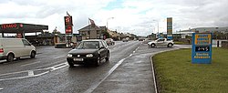
Bridgend, County Donegal
| Bridgend Irish: Ceann an Droichid | |
| County Donegal | |
|---|---|
 Traffic through Bridge End, County Donegal | |
| Location | |
| Grid reference: | C396217 |
| Location: | 55°2’30"N, 7°22’48"W |
| Data | |
| Population: | 454 (2016) |
| Local Government | |
| Dáil constituency: |
Donegal |
Bridgend or Bridge End is a village in County Donegal, standing at the base of the Inishowen peninsula. The village is on the road to Letterkenny, near the border with the United Kingdom, on the western outskirts of Londonderry.
History
Bridgend was one of several Protestant villages in eastern Donegal that would have been transferred to Northern Ireland, had the recommendations of the Irish Boundary Commission been enacted in 1925.[1]
Parish and townlands

Bridgend is part of Fahan parish which takes in Fahan, Burt and Inch.
The main townlands of Bridgend include Carrowreagh and Bunamayne (or Bonemaine; Bun na Maighne).[2] They are divided by a river which runs through Bridgend, with Carrowreagh to the north and Bunamayne to the south of the river. Other townlands of Bridgend include Tummock which is a back road running parallel to the Burt main road.
Outside links
| ("Wikimedia Commons" has material about Bridgend, County Donegal) |
References
- ↑ "Irish Boundary Commission Report". National Archives. 1925. p. 140–43. http://discovery.nationalarchives.gov.uk/details/r/C386829.
- ↑ "Bun na Maighne/Bunnamayne". https://www.logainm.ie/en/15089?s=bunnamayne.
