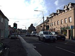
Rathcormac
| Rathcormac Irish: Ráth Chormaic | |
| County Cork | |
|---|---|
 Rathcormac's main street | |
| Location | |
| Grid reference: | W804920 |
| Location: | 52°4’37"N, 8°16’55"W |
| Data | |
| Population: | 1,762 (2016) |
| Local Government | |
| Dáil constituency: |
Cork East |
Rathcormac is a small town in north County Cork. Previously situated on the main Cork to Dublin road (the N8), it was bypassed in 2006 by the M8. The former N8 through the town's main street is now the R639 regional road. It is within the Blackwater Valley.
The name of the place name is from the Irish Ráth Chormaic, meaning 'Cormac's ringfort'.
History
Carntierna, an Iron Age royal site, is located to the north.
On 18 December 1834, during the Tithe War, the Rathcormac massacre occurred at Bartlemy Cross south-east of Rathcormac. On that day soldiers descended upon the home of a widow, Johanna Ryan, to enforce the collection of tithes and were met by local people protesting their actions. The outraged villagers threw piles and stones towards the soldiers, who fired on the crowd, killing between twelve and twenty civilians.
Sports
- Gaelic sports: Bride Rovers GAA
- Shooting: Rathcormac Gun Club[1]
| ("Wikimedia Commons" has material about Rathcormac) |
