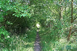
Pye Hill
| Pye Hill | |
| Nottinghamshire | |
|---|---|
 Path Near Pye Hill | |
| Location | |
| Grid reference: | SK449523 |
| Location: | 53°3’45"N, 1°20’24"W |
| Data | |
| Post town: | Alfreton |
| Postcode: | DE55 |
| Local Government | |
| Council: | Ashfield |
| Parliamentary constituency: |
Ashfield |
Pye Hill is a hamlet in the very west of Nottinghamshire, beside the River Erewash, which forms the border with Derbyshire to the west. Immediately to the south is Jacksdale, and Pye Hill forms effectively a north-western extension of the latter. Pye Hill is thus the westernmost place in Nottinghamshire.
The B600 road runs east–west through the hamlet, to Jacksdale to the south-east and across the river to Ironville in Derbyshire to the west.
The village was once served by the Pye Hill and Somercotes railway station, on the line running up the Erewash Valley.
| ("Wikimedia Commons" has material about Pye Hill) |

This Nottinghamshire article is a stub: help to improve Wikishire by building it up.
