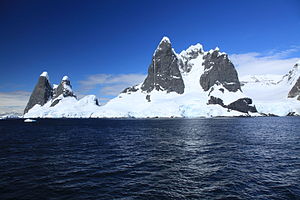
False Cape Renard

False Cape Renard is a rocky cape one and a half nautical miles south-west of Cape Renard, where the Danco Coast adjoins the Graham Coast of Graham Land in the British Antarctic Territory.
The headland was charted by the Belgian Antarctic Expedition under Gerlache (1897–1899), when a landing was made in the vicinity and the name The Needles was applied collectively to this feature and Cape Renard, which are similar in appearance. The name "The Needles" was applied by Henryk Arctowski, geologist, oceanographer and meteorologist with the Belgian expedition. Since the two capes are easily confused and need to be distinguished, a collective name is considered unsuitable. The name "False Cape Renard" was applied by the French Antarctic Expedition of 1908–1910 under Jean-Baptiste Charcot.
The feature was photographed from the air by the Falkland Islands and Dependencies Aerial Survey Expedition in the 1956-57 season.
Location
- Location map: 65°1’40"S, 63°49’1"W
References
- Gazetteer and Map of The British Antarctic Territory: False Cape Renard