Hopwell
| Hopwell | |
| Derbyshire | |
|---|---|
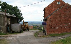
 Hopwell Hall Farm | |
| Location | |
| Grid reference: | SK443364 |
| Location: | 52°55’12"N, 1°21’0"W |
| Data | |
| Population: | 33 (2011) |
| Post town: | Derby |
| Postcode: | DE7 |
| Dialling code: | 0115 |
| Local Government | |
| Council: | Erewash |
| Parliamentary constituency: |
Erewash |
Hopwell is a tiny hamlet in the south-east of Derbyshire, linked to the public roads only by minor tracks and a bridleway. The population of the civil parish at the 2011 census was 33.
History
Appearing in the Domesday Book Survey of 1086, Hopwell was a village recorded as within the Morleystone Hundred of Derbyshire. It had a recorded population of 14.3 households in 1086.[1]
The most notable building in the parish is Hopwell Hall, built in 1720. It was owned by five generations of the Pares family from 1786 to 1921. The hall was demolished after a fire in 1957 and a new building was erected on the site. The large private house on the site is also called Hopwell Hall.
Outside links
| ("Wikimedia Commons" has material about Hopwell) |
References
- ↑ Hopwell in the Domesday Book
