Dalbury
| Dalbury | |
| Derbyshire | |
|---|---|
 All Saints, Dalbury | |
| Location | |
| Grid reference: | SK264343 |
| Location: | 52°54’20"N, 1°36’30"W |
| Data | |
| Postcode: | DE6 |
| Local Government | |
| Council: | South Derbyshire |
Dalbury is a tiny hamlet in the south of Derbyshire, at the end of a short, dead-end lane in open county, two miles outside the edge of Mickleover, an outermost suburb of Derby.
The nearest village of any size is Etwall, a mile and a half to the south, to which Dalbury is connected only by footpaths. Trusley, to the north-west is barely bigger that Dalbury itself.
Church
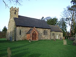
There is a church in Dalbury, All Saints. The church dates from the 13th century and was restored in 1844 (which drew contrinbutions form a wide circle, including £20 from the Queen Dowager, Queen Adelaide). The church is a Grade II* listed building.[1]
| ("Wikimedia Commons" has material about Dalbury) |
References
- ↑ National Heritage List 1334550: Church of All Saints, Dalbury (Grade II* listing)
