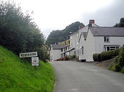
Stepaside, Montgomeryshire
| Stepaside | |
| Montgomeryshire | |
|---|---|

| |
| Location | |
| Grid reference: | SO082896 |
| Location: | 52°29’49"N, 3°21’8"W |
| Data | |
| Postcode: | SY16 |
| Local Government | |
| Council: | Powys |
Stepasidde is a hamlet in Montgomeryshire, just south-west of Newtown, along a local road from the town up the constricting valley of the Mochdre Brook (a stream which joins the River Severn in the town).
Stepaside finds itself in the gap between the two main westward routes out of Newtown.

This Montgomeryshire article is a stub: help to improve Wikishire by building it up.