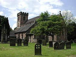
Standon, Staffordshire
| Standon | |
| Staffordshire | |
|---|---|

| |
| Location | |
| Grid reference: | SJ814350 |
| Location: | 52°54’43"N, 2°16’37"W |
| Data | |
| Population: | 879 (2011) |
| Post town: | Stafford |
| Postcode: | ST21 |
| Dialling code: | 01782 |
| Local Government | |
| Council: | Stafford |
| Parliamentary constituency: |
Stone |
Standon is a village in Staffordshire, about ten miles from the city of Stoke-on-Trent. There is limited road access, with the nearest major road being the A519 which runs through the neighbouring village of Cotes Heath. The parish population in 2011 was 879.
The parish church is the Church of All Saints. Associated with it is the village school, All Saints C of E First School.[1]
The name 'Standon' appears to come from the Old English stænen dun, meaning 'Stone Hill'.[2]
Parish church
There has been a church in the village since before the Domesday Book, which records it in 1086. The current church, All Saints, was rebuilt in 1847, except the middle aisle and the tower.[3] It has since been restored three times, with extensive work happening to the roof.[4] It is a Grade I listed building.[5]
The Church is a part of a benefice formed of four parishes: Cotes Heath, Swynnerton with Yarnfield, Standon and Tittensor, and these are known as 'The CoSST Churches'.[6]
History
According to the Domesday Book from 1086, Standon had nine households which is considered quite small, with 11 villagers, three smallholders, three slaves and one priest. The Lord of Standon in 1086 was Brian of Rauceby and the recorded Tenant-in-Chief was Robert of Stafford. In 1086 there were six ploughlands, of which one was owned by the Lord of Standon and five were for men's plough teams. Before the Conquest, the Lord of Standon was recorded to be Siward.[7]
John Marius Wilson described Standon in the Imperial Gazetteer of England and Wales as:
- "STANDON, a parish, with a village, in Stone district, Stafford; on the Northwestern railway, 4 miles NNW of Eccleshall. It has a r. station, called Standon-Bridge, and a post-office under Eccleshall."[8]
In 1885, The Standon Home was established as the only second boy's home in the Waifs and Strays' Society. Miss Maria Anderdon laid the foundation stone after she donated £2,000 to the new home. It initially housed 50 boys but after building work in 1892, numbers increased to 90, having built a new kitchen, a scullery and a large dormitory. The home was a purpose-built farm and was well equipped to train boys in agricultural skills, with much of their produce sold at local markets along with a regular stall kept in the Potteries towns. They cultivated over 50 acres of land which was leased from Thomas Salt MP. The Home closed in 1947.[9]
Standon Hall, which was built circa 1910, to the design of Liverpool architect J. Francis Doyle, is a manor house located in Standon. The Hall was formally owned and built for Sir Thomas Anderton Salt, a director of the North Staffordshire Railway company, but its use as a family home was short-lived, it being sold to Staffordshire County Council in 1925 for hospital use. In the 1930s pavilions for tuberculosis patients were built in the grounds whilst the principal activity at the site was orthopedic treatment. Upon the opening of Stafford General Hospital in 1983, the NHS sold the property into the private sector and the manor house itself converted into a residential care home for up to 22 elderly ladies and gentlemen, with the outbuildings, by now known as "The Beeches", specialising in dementia care for an additional 21 elderly residents.[10]
References
- ↑ All Saints, Mill Lane: English Heritage Days Out
- ↑ "Standon: Place Name Meaning". Key to English Place-names. The University of Nottingham. http://kepn.nottingham.ac.uk/map/place/Staffordshire/Standon. Retrieved 25 February 2014.
- ↑ White, William (1851). History, The Gazetteer and Directory of Staffordshire. Sheffield.
- ↑ "Standon All Saints, Standon". The Church of England. http://www.achurchnearyou.com/standon-all-saints/. Retrieved 25 February 2014.
- ↑ National Heritage List 1039004: Church of All Saints (Grade I listing)
- ↑ "Standon: The CoSST Churches". The CoSST Churches. http://cosst.org.uk/website/. Retrieved 25 February 2014.
- ↑ Standon, Staffordshire in the Domesday Book
- ↑ Wilson, John Marius: Imperial Gazetteer of England and Wales (A. Fullerton & Co., 1870)
- ↑ "Standon Farm Home for Boys". Hidden Lives Revealed, A Virtual Archive- Children in Care 1881-1981. http://www.hiddenlives.org.uk/homes/STAND01.html. Retrieved 27 March 2014.
- ↑ "Standon Hall Care Home". Caring Homes. Caring Homes. http://www.caringhomes.org/find-a-home/standon-hall/. Retrieved 4 March 2014.