Rialto
| Rialto | |
| County Dublin | |
|---|---|
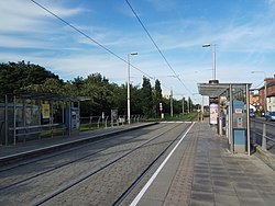
 Rialto Luas stop | |
| Location | |
| Grid reference: | O135331 |
| Location: | 53°20’10"N, 6°17’49"W |
| Data | |
| Postcode: | D8 |
| Dialling code: | 01 |
| Local Government | |
| Council: | Dublin |
| Dáil constituency: |
Dublin South-Central |
Rialto is an inner suburb of Dublin, south of the city centre.
History and Geography

Rialto is bounded to the east and north by The Liberties, St James's Hospital and an original section of the Grand Canal stretching from Suir Bridge to James Street Basin, which was built for freight transport to and from the nearby Guinness brewery at St James's Gate. This original section of the Grand Canal, disused since 1976, preceded an extension of the canal to Grand Canal Dock which today defines the district's southern and eastern edges.
Dublin's Rialto has its own Rialto Bridge which spans the original and disused portion of the Grand Canal which now forms part of the Luas Red Line.
Transport
Rialto is located within Dublin's canal ring and at the western end of Dublin's South Circular Road, placing the area within walking distance of Dublin city centre and one of Ireland's main railway stations at Dublin Heuston.
The original portion of the Grand Canal running along the northern edge of Rialto and Fatima has in recent decades been repurposed as the Luas Red Line route connecting Dublin's Docklands at The Point and the city's southwestern suburbs at Tallaght. Rialto Luas stop is located a short distance from the Rialto Bridge and serves Rialto as well as the neighbouring district of Kilmainham.