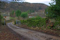
Skelton, Marske
| Skelton | |
| Yorkshire North Riding | |
|---|---|
 Approaching Skelton | |
| Location | |
| Grid reference: | NZ095008 |
| Location: | 54°24’12"N, 1°51’17"W |
| Data | |
| Post town: | Richmond |
| Postcode: | DL11 |
| Local Government | |
| Council: | Richmondshire |
| Parliamentary constituency: |
Richmond (Yorkshire) |
Skelton is a small hamlet in the North Riding of Yorkshire, in the area known as Richmondshire.[1] It is in the parish of Marske, less than a mile north-west of Marske village itself, which sits in Swaledale. The hamlet is five miles west of Richmond, Swaledale’s and Richmondshire’s main town.
The hamlet is within the Yorkshire Dales National Park.
Along with several other villages named ‘Skelton' in Yorkshire, the name derives from the Old English for ‘Farm on a shelf of land'’.[2][3]
During the 17th century, on the moors around Skelton were several lead mines.[4]
References
- ↑ Information on Skelton, Marske from GENUKI
- ↑ Chrystal, Paul (2017). The Place Names of Yorkshire; Cities, Towns, Villages, Rivers and Dales, some Pubs too, in Praise of Yorkshire Ales (1 ed.). Catrine: Stenlake. p. 73. ISBN 9781840337532.
- ↑ Ekwall, Eilert, The Concise Oxford Dictionary of English Place-Names. Oxford, Oxford University Press, 4th edition, 1960. p. 424 ISBN 0198691033
- ↑ "Mining and Smelting in the Markse Area, Swaledale" (PDF). 1994. p. 33. https://www.nmrs.org.uk/assets/pdf/BM50/BM50-24-40-marske.pdf. Retrieved 10 December 2018.
- History of Skelton, in Richmondshire and North Riding: A Vision of Britain