Mochdre, Montgomeryshire
| Mochdre | |
| Montgomeryshire | |
|---|---|
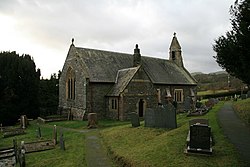
 All Saints, Mochdre | |
| Location | |
| Grid reference: | SO09449009 |
| Location: | 52°29’17"N, 3°22’7"W |
| Data | |
| Population: | 494 (2011) |
| Post town: | Newtown |
| Postcode: | SY16 |
| Local Government | |
| Parliamentary constituency: |
Montgomeryshire |
Mochdre is a small village and larger parish in Montgomeryshire. The civil community includes Penstrowed (which claims to be the smallest hamlet in Wales)[1] and the much larger settlement of Stepaside. It had a population of 494 as of the 2011 UK Census.
Geography
About three miles south-west of Newtown, it is near the River Severn.[2] Its tributary, Mochdre Brook runs through the village in a narrow steep-sided valley.[3]
Name
The name means "pigs' settlement", from moch, meaning pigs, and tre for settlement or town. It is possible that the name refers to Mochdre in the Fourth Branch of the Mabinogion, the tale of Math, son of Mathonwy, where Gwydion takes the pigs of Pryderi, staying overnight between the nearby commote of Ceri and Arwystli.
History
In 1872, the parish was recorded in the Newtown district, and spelled Moughtrey or Mochtref, with Eskirgilog and Moughtreyllan townships. At that time, there were 95 houses, a population of 526, and was 5,025 acres.[2]
The church, in the diocese of St Asaph in the late 19th century, was an ancient church in poor shape as of 1859.[2] With a roof dating from the 15th century, the rest of the Church of All Saints was rebuilt in 1867.[3] All Saints is a parish of the Mission Area of Cedewain, Church in Wales.[4]
Lake Mochdre, a former reservoir, later a fish farm, now a fishing venue, was created by damming a tributary stream.
References
- ↑ "History of Mochdre with Penstrowed". Mochdre with Penstrowed Community Council. http://www.mochdrepenstrowedcommunity.net/history/. Retrieved 16 September 2018.
- ↑ 2.0 2.1 2.2 John Marius Wilson (1872). "Imperial Gazetteer of England and Wales". http://www.visionofbritain.org.uk/place/8232. Retrieved 23 May 2017.
- ↑ 3.0 3.1 "Church of All Saints , Mochdre". http://www.cpat.demon.co.uk/projects/longer/churches/montgom/16912.htm. Retrieved 23 May 2017.
- ↑ "All Saints, Mochdre". http://www.churchinwales.org.uk/structure/places/churches/?id=1309. Retrieved 23 May 2017.