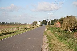
Harts Ground
| Harts Grounds | |
| Lincolnshire | |
|---|---|
 Harts Ground | |
| Location | |
| Grid reference: | TF208532 |
| Location: | 53°3’45"N, 0°11’56"W |
| Data | |
| Post town: | Boston |
| Postcode: | LN4 |
| Local Government | |
| Council: | Boston |
| Parliamentary constituency: |
Boston and Skegness |
Harts Ground or Harts Grounds is a hamlet on Holland Fen in Holland, the south-eastern part of Lincolnshire, and forming part of the long, thin, linear village of North Forty Foot Bank. It is a farm and cluster of cottages found nine miles north-west of Holland's main town, Boston.
Harts Ground was formerly an extra-parochial area, prone to flooding prior to the drainage of Holland Fen in 1767.[1] It was, and remains today, an area of isolated farms.[2]
Harts Grounds Farmhouse dates to the late 18th century, built in rendered brick with a pantile roof, and is a Grade II listed building.[3][4]
Outside links
References
- ↑ Pishey Thompson (1856). The History and Antiquities of Boston. Longman. p. 355. https://archive.org/details/historyandantiq04thomgoog. Retrieved 6 May 2011.
- ↑ Hart's Grounds settlement: Lincs to the Past
- ↑ Hart's Grounds Farmhouse: Lincs to the Past
- ↑ National Heritage List 1165097: Harts Grounds Farmhouse (Grade II listing)