Torc Mountain
| Torc Mountain | |||
| County Kerry | |||
|---|---|---|---|
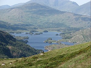
 From the summit of Torc Mountain looking to the Upper Lake | |||
| Range: | Mangerton Mountains | ||
| Summit: | 1,755 feet V955839 52°0’0"N, 9°31’0"W | ||
Torc Mountain is raises to 1,755 feet in the east of County Kerry, in a group known as the Mangerton Mountains. It is reckoned according to the Aderin list to be the 329th–highest peak in Ireland
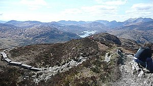
Torc is a popular mountain for hill walkers as it has a stone or boarded path (using railway sleepers) from its base at Torc Waterfall to its summit, which has views of the Lakes of Killarney.[1]
The Torc Waterfall is a beautiful cascade where the Owengarrif River plunges down the side of the mountain's chasms, and a popular visitor attraction, being close by the Lakes of Killarney. The waters flow down to Muckross Lake.
Name
The word Torc comes from the Irish translation of a "wild boar", and the area is associated with legends involving wild boars. One legend is of a man who was cursed by the Devil to spend each night transformed into a wild boar, but when his secret was revealed by a local farmer, he burst into flames and disappeared into the nearby Devil's Punchbowl on Mangerton Mountain from which the Owengarriff River emerged to hide the entrance to his cave beneath the Torc Waterfall.[2][3] There is also the story of how the legendary Irish warrior, Fionn MacCumhaill, killed a magical boar on Torc mountain with his golden spear.[4]
Geography
Torc Mountain is part of the Mangerton Mountains group, a massif to the south of Killarney that includes twenty-six other named peaks with a height above 328 feet.[5] Torc sits in the north-west corner of the massif and immediately west of Torc Mountain is the subsidiary summit of Torc Mountain West Top 1,542 feet.[6][7]
Torc's height and prominence qualify it on the British Isles 'Marilyn' classification,[8] as well as the Arderin classification of Irish hills.[5]
Ascent

A car park is provided for visitors to the Torc Waterfall, and most walks will begin here. There are footpath signs leading to a broad path up the mountain.
The initial path leads through the woods on the flank of Torc up to a viewpoint beneath the main falls. It is a popular spot as the falls are reckoned to be one of the finest waterfalls in Ireland.
From the viewpoint the path becomes a small road (the Old Kenmare Road) which leads further up the mountain, its surface strengthened with railway sleepers, and these the summit can be reached, at 1,755 feet.[7]
The route can thus be completed without full hiking boots, and requires no special navigational skills.[7][9]

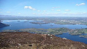
The summit of Torc has views of the Lakes of Killarney, the Black Valley, the MacGillycuddy's Reeks and Muckross House and grounds.[1] The route from the Torc Waterfall car-park (at V966847), to the summit of Torc Mountain and back is five miles and takes three hours.[1]
An alternative route, avoiding the hundred or so steps of the Torc Waterfall path, starts from the upper Torc Waterfall car-park (V967842), cutting almost half a mile off the route to the summit.[1][6]
The northerly views from the summit of Torc Mountain can be achieved by climbing the steep stone steps up the lower Cardiac Hill, which is half-way up the north facing slopes of Torc Mountain, and which can be accessed from the N71 Road, half a kilometre from the Torc Waterfall car-park.[10][11]
Outside links
| ("Wikimedia Commons" has material about Torc Mountain) |
- Torc Mountain: MountainViews
- Logainm: Placenames Database of Ireland
- Torc Mountain Walking Route, Map and GPS information from the Activeme site
References
- ↑ 1.0 1.1 1.2 1.3 Fairbairn, Helen: 'Ireland's Best Walks: A Walking Guide' (Collins, 2014) ISBN 978-1848892118: Route 46: Torc Mountain
- ↑ "Torc Waterfall Walk". Gems Publishing Limited. http://www.kerrygems.com/kerry-gems-app/the-best-walks-in-kerry/torc-waterfall-walk/.
- ↑ "Loop 10: Torc Waterfall". Discover Ireland. https://www.discoverireland.ie/getmedia/6ee4e83f-bf01-48d0-88f6-3e3ae70edcf4/KerryWalkingMaps.aspx.
- ↑ Donald E. Meek (July 1990). "THE DEATH OF DIARMAID IN SCOTTISH AND IRISH TRADITION". Dublin Institute for Advanced Studies. https://www.dias.ie/wp-content/uploads/webstore/celt/pubs/celtica/c21/c21-335.pdf.
- ↑ 5.0 5.1 Mountainviews, (September 2013), "A Guide to Ireland's Mountain Summits: The Vandeleur-Lynams & the Arderins", Collins Books, Cork, ISBN 978-1-84889-164-7
- ↑ 6.0 6.1 Paddy Dillon (10 March 2005). The Irish Coast to Coast Walk: Dublin to Bray Head. p. 156. ISBN 978-1852844332. "Day 21: Muckross to Black Valley"
- ↑ 7.0 7.1 7.2 Jim Ryan (1 October 2012). Scenic Walks in Killarney. Collins Press. ISBN 978-1848891463. "Walk 11: Torc Waterfall Circuit"
- ↑ "The Database of British and Irish Hills". Database of British and Irish Hills. 2018. http://www.hills-database.co.uk/downloads.html.
- ↑ 'Torc Mountain': Grace Harding in The Idyll 21 January 2017
- ↑ "Cardiac Hill, Torc Mountain". KillarneyGuide.ie. https://killarneyguide.ie/cardiac-steps/.
- ↑ Seán Kenehan (24 November 2018). "This Unassuming Walking Trail has some of the Most Spectacular Views in Ireland". Lovin.ie. https://lovin.ie/counties/kerry/cardiac-steps-torc-mountain-walk-killarney.
Books
- Fairbairn, Helen: 'Ireland's Best Walks: A Walking Guide' (Collins, 2014) ISBN 978-1848892118
- Stewart, Simon: 'A Guide to Ireland's Mountain Summits: Vandeleur-Lynams & Arderins' (Collins, 2013) ISBN 978-1-84889-164-7
- Ryan, Jim: 'Carrauntoohil and MacGillycuddy's Reeks: A Walking Guide to Ireland's Highest Mountains' (Collins, 2006) ISBN 978-1905172337
- Dillion, Paddy: 'The Mountains of Ireland: A Guide to Walking the Summits' (Cicerone, 1993) ISBN 978-1852841102
