West Compton, Dorset
| West Compton | |
| Dorset | |
|---|---|
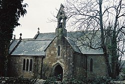
 Parish church of St Michael | |
| Location | |
| Grid reference: | SY562943 |
| Location: | 50°44’46"N, 2°37’5"W |
| Data | |
| Population: | 24 (2013 estimate) |
| Post town: | Dorchester |
| Postcode: | DT2 |
| Local Government | |
| Council: | Dorset |
| Parliamentary constituency: |
West Dorset |
West Compton is a hamlet in the west of Dorset, sitting about seven miles to the east of the town of Bridport, while county town, Dorchester, stands some nine miles to the east. The A35 trunk road, which runs between these two towns, is about two miles to the south.
An estimate in 2013 had the parish population at 24.
West Compton stands at the head of a small valley, formed by a tributary of the River Frome. The surrounding chalk hills are part of the westerly edge of the Dorset Downs, which here reach a height of 827 feet at Eggardon Hill, just over a mile to the west.
Outside links
| ("Wikimedia Commons" has material about West Compton, Dorset) |
