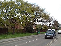
Sandford, Dorset
| Sandford | |
| Dorset | |
|---|---|
 Sandford Road | |
| Location | |
| Grid reference: | SY931898 |
| Location: | 50°42’28"N, 2°5’49"W |
| Data | |
| Local Government | |
| Council: | Dorset |
| Parliamentary constituency: |
Mid Dorset and North Poole |
Sandford is a village in Dorset, on the A351 road some two miles from Wareham and seven miles from Poole.
Sandford forms the only significant settlement within the civil parish of Wareham St Martin, which otherwise covers much of the rural area to the north of Wareham.
To the north of Sandford is Gore Heath, part of Wareham Forest, which is the subject of a controversial proposal for gravel extraction.[1][2]
Outside links
| ("Wikimedia Commons" has material about Sandford, Dorset) |
References
- ↑ Dorset gravel plan for forest gets over 200 objections at www.bbc.co.uk. Retrieved 14 Dec 2014
- ↑ 'Gravel plan to ‘destroy’ area' in The Bournemouth Echo
