Glanvilles Wootton
| Glanvilles Wootton | |
| Dorset | |
|---|---|
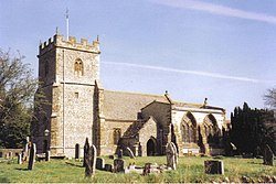
 Parish church of St Mary | |
| Location | |
| Grid reference: | ST678082 |
| Location: | 50°52’21"N, 2°27’35"W |
| Data | |
| Population: | 196 |
| Post town: | Sherborne |
| Postcode: | DT9 |
| Local Government | |
| Council: | Dorset |
| Parliamentary constituency: |
West Dorset |
Glanvilles Wootton, or Wootton Glanville, is a village in Dorset, in the Blackmore Vale under the scarp of the Dorset Downs, five miles south of Sherborne. The 2011 census recorded a parish population of 196.
To the north of the village is Round Chimneys Farm, which used to be a manor house and home of John Churchill, 1st Duke of Marlborough.[1] One mile south-east of the village is a hill fort on Dungeon Hill.
Outside links
| ("Wikimedia Commons" has material about Glanvilles Wootton) |
References
- ↑ Ralph Wightman (1983). Portrait of Dorset. Robert Hale Ltd. pp. 139–140. ISBN 0 7090 0844 9.
