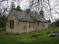
Shipton, Gloucestershire
| Shipton | |
| Gloucestershire | |
|---|---|
 St Oswald's Church in Shipton Oliffe | |
| Location | |
| Grid reference: | SP038186 |
| Location: | 51°51’59"N, 1°56’45"W |
| Data | |
| Postcode: | GL54 |
| Local Government | |
| Council: | Cotswold |
| Parliamentary constituency: |
The Cotswolds |
Shipton is a village of the Gloucestershire Cotswolds consisting of the twin villages named Shipton Oliffe (to the east) and Shipton Solars (to the west) which have run together. These are found just seven miles from Cheltenham.
The River Coln, just a tiny stream at this point, flows through the village over two fords and innumerable little water splashes, creating ornamental lakes in private properties.[1] The population of the parish at the 2011 census was 365.[2]
The name Shipton, meaning "sheep farmstead", indicating the long reliance of these hills on sheep farming.[3] The Domesday Book refers to two manors, Oliffe and Solers, each with its own church. In 1871, they were united as one parish.[3]
The Gloucestershire Way long-distance footpath passes through the village.
Outside links
| ("Wikimedia Commons" has material about Shipton, Gloucestershire) |
References
- ↑ "The story of our village". The Shipton History Project. https://shiptonhistoryproject.yolasite.com/overview.php. Retrieved 29 October 2019.
- ↑ "Parish population 2011". https://neighbourhood.statistics.gov.uk/dissemination/LeadKeyFigures.do?a=7&b=11128445&c=GL54+4JB&d=16&e=62&g=6427105&i=1001x1003x1032x1004&m=0&r=0&s=1427294780607&enc=1. Retrieved 25 March 2015.
- ↑ 3.0 3.1 A History of the County of Gloucester - Volume 9 pp 187-208: Parishes: Shipton Oliffe and Shipton Solers (Victoria County History)
