Epney
| Epney | |
| Gloucestershire | |
|---|---|
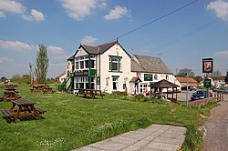
 The Anchor, Epney | |
| Location | |
| Grid reference: | SO763110 |
| Location: | 51°47’51"N, 2°20’41"W |
| Data | |
| Postcode: | GL2 |
| Local Government | |
| Council: | Stroud |
Epney is a small village in Gloucestershire on the eastern bank of the broadening River Severn downstream of Gloucester, eight miles south-west of Gloucester.
The village stands between Longney to the north and Upper Framilode to the south. The village has a pub called The Anchor Inn.[1] The population of the Longney and Epney parish was recorded as 285 in 2011.
The hamlet of Epney was first inhabited by the late 13th century,[2] Originally part of the Moreton Valence Parish and has been part of the Framilode ecclesiastical parish since 1855.[3] Since 1974 Epney has been allocated to the civil parish of Longney and Epney.
A small house in the village known as Doris's Cottage dates from the 15th century and is designated as a Grade II* listed building.[4]
| ("Wikimedia Commons" has material about Epney) |
References
- ↑ The Anchor Inn
- ↑ "Moreton Valence: Introduction". British History Online. http://www.british-history.ac.uk/vch/glos/vol10/pp205-208. Retrieved 7 August 2016.
- ↑ Template:VC
- ↑ National Heritage List 1155549: Doris's Cottage
