Andoversford
| Andoversford | |
| Gloucestershire | |
|---|---|
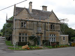
 Former Police station in Andoversford | |
| Location | |
| Grid reference: | SP024196 |
| Location: | 51°52’30"N, 1°57’56"W |
| Data | |
| Population: | 555 (2011) |
| Post town: | Cheltenham |
| Postcode: | GL54 |
| Local Government | |
| Council: | Cotswold |
| Parliamentary constituency: |
The Cotswolds |
Andoversford is a village in Gloucestershire, about six miles east of Cheltenham. The parish had a population of 555 at the 2011 census.
The village runs parallel to the A40 and is on the River Coln. Amenities include a post office, two community or village halls, a primary school, a local shop and pubs called the Royal Oak, the Kilkeney Inn, with The Frogmill Inn only a mile away too. The disused animal stock market has been developed into a small housing estate.
Community
The village has goodly range of local businesses for such a small place, and several meeting areas; pubs, schools, church, social club, and the playground.
Annual events include point to point events on the point to point course, village fetes, social evenings, quizzes, live music to name a few. These are organised by a group of local residents who formed the Andoversford Social Events Committee. The village also supports a football team, a cricket team, majorettes and has Cubs and Scout groups.
Andoversford is positioned close to four golf courses - Shipton Golf Course, Naunton Downs Golf Club, Cotswold Hills Golf Club and Lillybrook Golf Club.
Outside links
| ("Wikimedia Commons" has material about Andoversford) |
- Andoversford Football Club
- Ian Coley shooting
- Lilley Brook Golf Club
- Shipton Golf Course
- Cotswold Water Park
