Milbury Heath
From Wikishire
Revision as of 21:56, 2 December 2019 by RB (Talk | contribs) (Created page with "{{Infobox town |name=Milbury Heath |county=Gloucestershire |picture=The White Horse - geograph.org.uk - 314816.jpg |picture caption=The White Horse, Milbury Heath |os grid ref...")
| Milbury Heath | |
| Gloucestershire | |
|---|---|
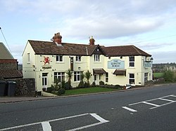
 The White Horse, Milbury Heath | |
| Location | |
| Grid reference: | ST666902 |
| Location: | 51°36’35"N, 2°29’1"W |
| Data | |
| Local Government | |
| Council: | South Gloucestershire |
Milbury Heath is a hamlet in Gloucestershire, located east of Thornbury in the south of the county. The hamlet has a garden centre and a few other farm shops. The heath is a local high point and offers views west across the Severn Vale, and north into the Vale of Berkeley.
The hamlet has a former (Methodist?) chapel now converted to a private house, and a duck-pond.
The hamlet is on the Avon Cycleway. Both the A38 road and M5 motorway pass nearby. Just to the north on the A38, (technically in Buckover), is the White Horse pub.
Outside links
| ("Wikimedia Commons" has material about Milbury Heath) |