Thruxton, Herefordshire
| Thruxton | |
| Herefordshire | |
|---|---|
 St Bartholomew's church, Thruxton | |
| Location | |
| Grid reference: | SO437346 |
| Location: | 52°0’25"N, 2°49’12"W |
| Data | |
| Population: | 33 (parish) |
| Post town: | Hereford |
| Postcode: | HR2 |
| Dialling code: | 01981 |
| Local Government | |
| Council: | Herefordshire |
| Parliamentary constituency: |
Hereford and South Herefordshire |
Thruxton is a small rural village in Herefordshire. It is within the historic area of Archenfield, near the Welsh border and the city of Hereford. The village lies west of the A465 road and just south of the B4348 road between Kingstone and Much Dewchurch.
The parish had a population of 33 at the 2001 UK Census.
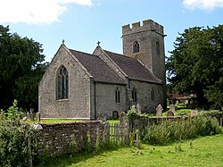
The parish church, dedicated to St Bartholomew, is mainly in the Decorated style.[1]
Outside links
References
- ↑ Nikolaus Pevsner: The Buildings of England: Herefordshire, 1963; 2012 Penguin Books ISBN 978-0-300-12575-7