Snabrough Broch
| Snabrough broch | |
|
Shetland | |
|---|---|
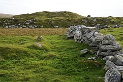
 Snabrough broch in the background | |
| Type: | Broch |
| Location | |
| Grid reference: | HP56830271 |
| Location: | 60°42’13"N, -0°57’39"W |
| History | |
| Built Iron Age | |
| Information | |
Snabrough Broch is a ruined broch on Shetland's northernmost island, Unst. It overlooks Snabrough Loch.
The broch m ay be found by the loch south of Burragarth, about 500 yards east of Bluemull Sound. It stands on a short, low promontory on the loch shore, and is surrounded to the north by rolling cultivable land.[1]
Description
Snabrough Broch has an external diameter of around 60 feet.[1] Little of its structure can be seen, but traces of the inner and outer faces of the broch wall are on the southeast side.[1] The entrance is on the north-west side, but is filled with debris.[1] The broch was visited by the antiquarian George Low in the 18th century, who noted "large hollow apartments ... following the curve of the wall"; these are no longer visible.[1]
On the landward side of the broch there was an outer wall or rampart with a ditch, which curved across the broad neck of the promontory.[1] Between the outer wall and the broch there may have been some out-buildings.[1]
Outside links
| ("Wikimedia Commons" has material about Snabrough Broch) |
References
| Prehistoric Shetland | |||
|---|---|---|---|
| Neolithic |
Benie Hoose • Funzie Girt • Hjaltadans Stone Circle • Pettigarths Field Cairns • Scord of Brouster • Standing Stones of Yoxie • Stanydale Temple • Vementry | ||
| Iron Age brochs |
Clickimin • Culswick • Mousa • Burra Ness • Clumlie • Huxter • Ness of Burgi • Snabrough • West Burrafirth | ||
| Pictish | Mixed period | ||
